As relieved as I am that my friends and family are not affected by the evacuation, I can't help be worried for others-listening to the news conferences, I easily get emotional at the idea of people being misplaced and away from their homes. Hopefully the dikes will hold the water and homes and businesses will be safe. In the meantime, here are some pictures that I want to share with you that I took. The last one is not one that I took that I was able to find from ebrandon.ca.
So this is the highway I take to travel to Brandon-the 83...in actuality, the part of the river is actually only what you see under the bridge and that is swollen twice its size still. Just south of Miniota.
Going towards the bridge, towards the Assiniboine. See the water on the side?
Here you can see how close the water is to the highway.
A dike on 18th on May 7th-they were building the dikes higher.
Looking at the dikes towards the west...that's not a lake...that's farmland.
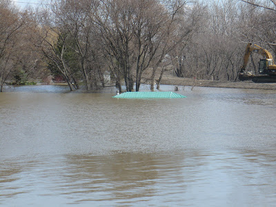
This is small park on the west side of 18th where the skating oval is in the winter. Notice the little hut is nearly underwater.
The road into Dinsdale Park is now a dike.
On the east side of the bridge on 18th...looking north.
Looking northeast. That's like a little hut in the background nearly buried by water.
A close up of the hut nearly under water. Beyond that is the amplitheatre where weddings and wedding pictures usually take place. That sure isn't happening this summer.
Near the skating oval once again off of 18th.
Bye bye barbeque...in the back..the machine is packing down the dike.
Looking east of 18th
Looking north. Notice the streetlight in the background?
Streetlight nearly buried. These lights are probably about a storey and a half tall? The walkway goes under the bridge along the river.
This picture not only shows the light so well but how fast the water was moving. The water at points seemed like rapids.
The new twinned bridges-east side. You can see how high the water is to the bridge.
Looking north east towards Kirkcaldy Drive and Conservation Drive.
The walkway no more...
Not my picture but truly shows how bad it is. This is along 1st just north of the bridge. In the background you can see the playground where I played as a child, and the train that at one time, you could actually climb into and play around. This scene is so heartbreaking for me. To see what you love become devastated...another interesting connection I have to this picture is that my great grandparent's house used to be located where the road/highway was-in order to build the road, they bulldozed many homes, including my great grandparents.


No comments:
Post a Comment